
by Ian Stephenson, Planning Subcommittee Convenor, Bulletin 7/2022, September 2022
Glebe’s well defined physical boundaries, unusually intact and layered urban fabric, remarkable history, topography and demography make it a unique suburb. Perhaps the most important quality of all is Glebe’s residents love of place. The Society has been working to nurture Glebe’s special magic for over fifty years. Active engagement with the planning process is an important part of this. The Society has been very busy in this area over the last year. Our work has included making submissions on development applications, participating in meetings with the City of Sydney and the NSW Land and Housing Corporation, Infrastructure NSW and making detailed submissions on State Significant Development.
I am going to report on our planning work using three headings: Visionary Projects, Opportunities and Threats. So, this is a VOT analysis not a SWOT analysis.
Visionary Projects
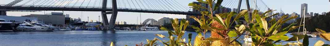
We all know Handel’s great tenor aria Every valley shall be exalted. One of the miracles of planning in Glebe has been the transformation of industrial wasteland into foreshore parks. These form our northern boundary. Recently Sydney Water completed the Johnstons Creek naturalisation and wetland project which forms our western boundary. This has been beautifully realised. Our eastern boundary, which is Wentworth Park, is the missing piece in the ensemble.
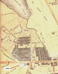
The park was created in 1882 from reclaimed land. The original scheme was artfully designed to accommodate active and passive recreation. Over the years it has been compromised but there are green shoots sprouting. The State Government has signalled its intention to remove the greyhound track.

The Society recommended to City of Sydney Council’s review of the Wentworth Park’s plan of management that there should be an integrated plan for the whole park. Pleasingly, Council is now in the process of developing a unified plan of management.
We also recommended that higher level planning documents for Sydney include Wentworth Park as a visionary project. This includes retaining the legibility of the topography on the park’s western edge, not burying it in a mountain of masonry, recovering and celebrating the area’s Indigenous significance – as well as a sense of the post-colonial gardenesque layout – and creating a green link which connects and interprets the former bay’s relationship to its extant headwaters, Lake Northam in Victoria Park. It can become a park like no other.
Opportunities
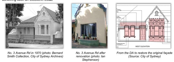
The Development Control Plans for Glebe include the objective, where feasible, of recovering lost details of buildings within heritage conservation areas. The Society has immense knowledge about the built form of Glebe. We see this as something to be shared. It was very pleasing to see our research inform the re-creation of the rich details of the façade of 3 Avenue Rd which had been removed in the 1970s (see Figure 3 below).
We also prepared a report documenting missing elements on the front elevation of a house in Boyce St and are hopeful that we will see a similar result there. The Society is always happy to share its knowledge of Glebe’s built environment with residents.
As outlined in Brian Fuller’s Heritage Convenor’s Report we met with Councillors and Planners to discuss the Local Environment Plan and Development Control Plan reviews. Nearly all of Glebe is within heritage conservation areas. These have quite detailed principles about managing development while retaining heritage significance. We would like to see it made easier for residents to access information about this, to understand what it means and get more guidance about the best way to extend their houses sympathetically. We are pleased to advise that Council are looking at diagrammatic exemplars as a means of providing greater clarity for applicants.
Threats
Glebe’s proximity to the city, the rising value of land and the fact that the State Government is Glebe’s largest property owner is putting pressure on the conservation of Glebe’s urban and social fabric.
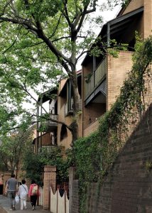
In the 1980s the NSW Housing Commission added the equivalent of 1,000 bedrooms of infill housing to Glebe. This included good work to heal the wounds left by the Department of Main Roads’ demolitions in the Lyndhurst estate for the Western Distributor. The brilliance of the work was that it fitted in with the scale of Glebe and included verandas and small front gardens so the new dwellings gave residents the same connection with the street as Glebe’s old houses.
Last year the Land and Housing Corporation removed 17-31 Cowper St and 2A-D Wentworth Park Rd from the St Phillips Heritage Conservation Area allowing for the construction of two eight-storey buildings. In November 2021 the development application was approved.
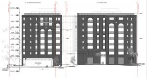
The Land and Housing Corporation now plan to demolish 82 Wentworth Park Rd. It was designed as part of the rehabilitation of the Lyndhurst estate after the Department of Main Roads demolitions and is part of an ensemble of three buildings (the other two being 49-55 and 61-63 Bellevue St) whose broken forms, pitched roofs and verandas use the topography to complement and reinforce Glebe’s traditional urban edge with Wentworth Park.
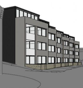
The cost of demolition and rebuilding is greater than refurbishment. This is a well-built and beautifully designed building – what is proposed is not. Demolition comes at a personal cost, as it dislocates long term tenants. Nor is it an environmentally sustainable option. The scheme provides little increase in the number of bedrooms and this will be at great expense.
It would be much better to refurbish and retrofit and provide additional housing through sensitive infill development.
It is a real concern that the NSW Land and Housing Corporation will continue to redevelop its larger sites in Glebe, thus overturning 50 years of good planning and destroying the character of our suburb.
The sale of old houses in the former church estates is another concern. They were purchased by the Federal Government in 1974 in order to maintain parts of Glebe for people on low incomes. They are an integral part of Glebe’s broad social demographic. These houses were put in good order by the Federal and State governments but have been woefully neglected in recent years.
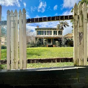
The controversial Bidura development continues to be a problem. The development application has not yet been determined. In the meantime, the old house, and particularly its front fence, continues to decay. Bidura is on the State Heritage list. The NSW Heritage Act defines minimum standards of maintenance for State Heritage listed items, including fences, and has provisions for their enforcement. The present condition of the fence of this landmark building is a blight on Glebe and should be remedied.
Other Work
The Society objected to the terms of renewal of the illuminated advertising on the Glebe Island silos, due to its intrusive effects on residences in parts of Glebe Point. We also recently gave evidence to the Independent Planning Commission on this matter. We objected to the application for a liquor licence at 387 Glebe Point Rd. The application has been withdrawn. During the year we made a number of other submissions in relation to development applications. These can be read on our website.
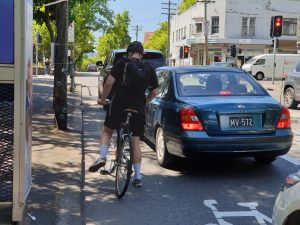
The Bridge Rd pop-up cycleway is a continuing concern. We are not opposed to cycleways but this one is unsafe for cyclists as it disappears in a number of places forcing them into the roadway or onto the footpath and is unfair to residents in the way it has removed all the parking on Bridge Rd. This has unacceptable impacts, particularly on carers. Regrettably, the Minister for Active Transport, the Hon. Rob Stokes, has not replied to our letters, and requests to meet with traffic planners to better understand the options and alternative have not been acceded to.
We made submissions to the NSW Department of Planning Industry and Environment on the Pyrmont Place Master Plan, particularly in relation to Wentworth Park, and also on the Bays West Masterplan and the State Significant Precinct Study for Blackwattle Bay, and its recent revisions. Asa Wahlquist, the Bays and Foreshores Convenor, will report on the latter two issues in the next Bulletin.
I would like to thank Brian Fuller, the Heritage Convenor, and the planning staff of the Council of Sydney for their help in unravelling the intricacies of the planning system, Rodney Hammett for his forensic research skills, Asa Wahlquist for her thorough and clear analysis of the Blackwattle Bay Masterplan, Jude Paul, Robert Hannon and Peter Crawshaw for helping with fieldwork and Virginia Simpson-Young for featuring planning in the Bulletin and the web.


There are no comments yet. Please leave yours.