

This is the second of three articles by Glebe Society Environment Subcommittee Convenor, Asa Wahlquist, focusing on the natural environment of Glebe and Forest Lodge.

In 1969 the only foreshore park in Glebe was Pope Paul VI Park, at the end of Glebe Point Rd. Very little of Glebe and Annandale was parkland: Glebe had only 40% of the area of parkland that was considered adequate at the time, while Annandale had only 16%.
Blackwattle Bay Park became the second link in the chain, when it was completed in 1983. Between Blackwattle Bay Park and Pope Paul VI Park the foreshore was still owned privately or by the State Government, and inaccessible to the public.
Beyond Pope Paul VI Park the Rozelle Bay waterfront was still occupied by a series of businesses on Maritime Board land. Federal Rd ran between the waterfront businesses and Jubilee Park. It crossed Johnstons Creek via the Truss Bridge. The Annandale side of Johnstons Creek was a timber yard.
Johnstons Creek was named after George Johnston of the NSW Corps. He was granted land on the other side of the creek, which he named Annandale, after his home town in Scotland.
The Creek originally spread across the valley, in the form of mudflats, estuarine wetlands and mangrove forest. The original shoreline can be traced around the edge of Jubilee and Federal Parks, past where the Tramsheds are today, across Harold Park.
Reclamation of the swamp land around the creek’s mouth began in 1886, creating the stormwater canal and the parklands on either side. A referendum rejected use of the land for industry only, and part of the reclaimed land was dedicated as parklands in 1899. It was named Federal Park in 1902 to commemorate the federation of the Australian colonies in 1901.

Johnstons Creek became a stormwater channel, and formed the boundary between Glebe and Annandale municipalities for over a century. Glebe’s section was renamed Jubilee Park in 1909 to mark 50 years of the municipality. Today both come under the City of Sydney Council; the western boundary is The Crescent.
Federal Rd was closed in the 1980s and its route is now marked by paving and the replica Allan Truss pedestrian bridge across the canal.
Pope Paul VI reserve was formerly called Marine Reserve. There was a wharf at the end of Glebe Point Rd and after Pope Paul VI disembarked from a launch there in 1970, to visit the Royal Alexandra Hospital for Children in Camperdown, it was renamed after him. Neither the wharf, nor the Hospital, are still there.
The Oldest Trees in Jubilee Park
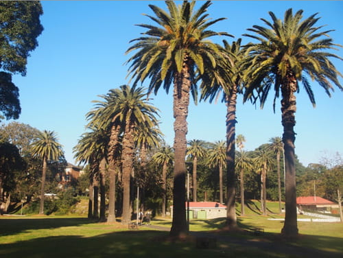
The oldest plantings in Jubilee were undertaken in the 1890s.
The formal avenue of 26 Canary Island Date, or Phoenix, Palms located immediately east of the oval, supported by an associated row planting of 13 palms, is believed to have been planted in 1935. The Canary Island Palm, with its drought tolerance and uniform and dramatic growth pattern, was often used in early commemorative parkland and civic landscapes, particularly in the Inter-war period.
However, a number of these plantings, particularly in Centennial Park, have recently been affected by a soil fungal pathogen, known commonly as Fusarium wilt. Fusarium wilt has been found in at least one of the Jubilee Park palms, and the remainder are expected to eventually fall victim to the disease for which there is currently no treatment.
The City of Sydney states that ‘the avenue of Canary Island Date Palms (Phoenix canariensis) is one of the most outstanding examples of civic planting using this species in the Sydney metropolitan area. This formal avenue (26 palms) and associated row planting (13 palms) has group significance at the City/ LGA [Local Government Area] level in terms of its commemorative, social, aesthetic and visual values.’9 [Footnotes are at the end of the article]
The Foreshore Walk, Blackwattle to Bicentennial Park
The creation of Bicentennial Park was a huge step towards the overriding plan for a foreshore walk from Bridge Rd to Annandale. But in 1988, between Bicentennial Park and Blackwattle Bay Park, several privately-owned waterfront properties were still blocking progress.
Over the decades the waterfrontage belonging to the privately held houses along Oxley, Stewart and Mary Sts was transferred to Council for the foreshore walk.
Sylvester Stride’s former ship-breaking yards are marked by one of his cranes, which remained to commemorate the site’s maritime industrial history. The small park opposite the end of Leichhardt St was won in an earlier campaign.
The acquisition of these properties began under Leichhardt Council, and the process speeded up when Glebe was transferred to the comparatively wealthy City of Sydney in May 2003. John Buckingham said: ‘The accelerated pace began under Lucy Turnbull, who came on our waterfront walk early in her short stint as [City of Sydney Lord] Mayor. She recognised the need to complete the transfer of the Anchorage waterfront site [the land behind 451 Glebe Point Rd] quickly, and the need to restore Bellevue which, by now, despite the holding operation 25 years ago, was in a desperate state of disrepair. The next Council, under Clover Moore, really got on with the job. She sees our foreshore walk as part of a foreshore walk right around the harbour’s southern shore contained within City of Sydney Council’s borders.’
Harbour Lighterage, below 18 Oxley St and now called Bridgewater, had a wharf and a collection of tugs. (Lighters are small boats that ferry goods from larger boats to shore). The transfer was settled in the Land and Environment Court. ‘We did not get what we wanted but the result is better than we might have expected,’ John said.
It took decades to obtain the waterfrontage to The Anchorage, at 451 Glebe Point Rd. Fifty years ago there was an old house and a derelict tennis court up the top, and the remains of a harbour pool down below. In 1974 the house was demolished and construction of the current buildings began. The waterfront level was left vacant, accessed by a steel ladder down the cliff. For 25 years Leichhardt Council’s approaches to purchase the waterfrontage were refused, but the City of Sydney proved more persuasive.10
In the 1960s there was a series of warehouses at the end of Glebe Point Rd, where The Pavilions now stands, owned by Hardy Brothers. By the late 1970s their old timber drying sheds were occupied by many creative types, including artists and boat builders. That building was sold to home unit developers, with the waterfront land given to council for park land being a condition of rezoning. The waterfront walk from Blackwattle Bay to Pope Paul VI Park was completed in 2005.
The Battle for Bicentennial Park
John Buckingham writes:
When then-Premier Bob Carr came to one of the park functions in 1988 during the development of Bicentennial Park Stage 1, he likened our campaign for waterfront open space to the Wars of the Roses – Bob’s a history, not a movie, buff! He was, no doubt, conscious of the intrigue, conspiracy and mayhem conducted along the way to our gaining this wonderful park.
The campaign for Bicentennial Park Stage 1 (the Glebe side) lasted 20 years. The campaign for Stage 2 (the Annandale side) was to take a little longer. In 1969 Federal Rd continued from Glebe Point Rd straight through what is now the centre of Bicentennial Park over Johnston Creek Canal, by what was then the road bridge, to Minogue Cresc.
Between Federal Rd and Rozelle Bay there were unused/misused (previously waterfront industrial) sites. At the bridge there was the long-since-abandoned Purr Pull petrol storage site. From there to Pope Paul VI Park there were sites that in an earlier era had been served by lighters and had housed legitimate waterfront timber millers – raw product in by water; finished product out by water.
By 1969 some of these sites were abandoned. Others were used as timber storage or as non-waterfront industrial timber workshops – in by truck, out by truck. From its inception, the Glebe Society has had a policy of supporting legitimate small scale waterfront industry in our bays, but these sites had ceased to function within that policy.
During the first 15 years of our campaign we had no formalised plan for the potential park. We had vague ideas of what it should look like, but our emphasis was on trying to have the politicians recognise the logic of our arguments – these sites were not being used for their zoned purpose, so they should be handed over for open space.
It was the coming of the Evan Jones/Nick O’Neill Leichhardt Council, the approaching Bicentenary and real plans to take to the politicians that gave us our boost. Now that they were actively interested. Leichhardt Council formed a Bicentennial Committee, and as Glebe Society representative, Neil Macindoe’s job was to make sure the Bicentennial Park remained at the top of the list for the next four years.
There were more trials and tribulations along the way: the State government’s attempt to offer Stage 1 if Stage 2 were to become a marina; squatters taking over some of the buildings after the decision had been taken by the government to develop the park and asbestos discovered prior to demolition.’11
Note: When Bicentennial Park was opened in 1988, John points out the park was not complete because the fountain from the original plan had not been built. That is still the case today.
Bringing Back Marine Biodiversity
Both Blackwattle and Rozelle Bays are blind-ending bays that experience very little flushing. Add to that the early days when raw sewage and industrial waste flowed freely into the bays, the destruction of the mangrove forests and the replacement of the entire natural waterfront with sea walls, and the result is dramatically reduced biodiversity.
In 2006 commercial fishing was banned in Sydney Harbour. While recreational fishing has not been banned, the Department of Primary Industries advises that fish and crustaceans caught west of Sydney Harbour Bridge, which includes the Bays, should not be eaten.12
Fishing blogs report that bream, whiting, chopper tailor, flathead, mullet, leatherjacket and jewfish have been caught in Rozelle Bay.
Rebecca Morris, formerly from the Coastal and Marine Ecosystems Group at the University of Sydney, has studied the marine life of the Bays. Rebecca, along with Associate Professor Ross Coleman, set up a ‘green engineering’ project in the Bays, a series of flowerpots attached to the sea walls.
Ross points out that the pre-European Harbour consisted of a mixture of rocky headlands, sandy beaches, salt marshes and mangrove forests. That has been replaced by seawalls around the Bays, with the exception of two small areas of restored mangroves. Seawalls lack the myriad nooks and crannies marine animals need for habitat.

The flowerpot is a half pot attached to a seawall that provides missing habitat, with cameras installed to observe the species. The flowerpot project received a grant from the City of Sydney. The project found that before the flowerpots were installed, there were maybe nine species. After installation 40 species were observed, with 28 species in the flowerpots, including algae, snails and starfish, and small fish at high tide.13
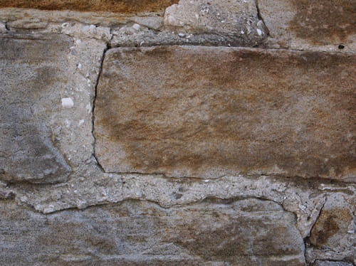
At the time of settlement, Sydney Harbour had huge oyster reefs, so large that ships had to navigate around them. Oyster shells have a high lime content, and were harvested in enormous quantities to make mortar for early buildings. Aboriginal middens were also raided for the shells. Fragments of shell can be seen in the mortar of some of Glebe’s oldest buildings.
As a result, most of Sydney’s oyster beds were wiped out, and the native flat oyster, Ostrea angasi was eliminated. The Sydney Institute of Marine Science is working to restore the lost oyster reefs, and to bring back the angasi species. Their first experimental site is in Botany Bay, but they are also looking for safe sites in Sydney Harbour. Oysters clean up the water, filtering out excess nutrients and heavy metals. The reefs provide habitat for many sea creatures, like snails and crabs, which in turn attract fish. Oyster reefs can also act as a buffer against wave damage.14
The Polluted Bays
Blackwattle and Rozelle Bays are amongst the most polluted in the Harbour.
In 2015 a study assessing pollution in Sydney Harbour gave Blackwattle and Rozelle Bays, along with Iron Cove and Homebush Bays, the lowest grade.
The pollution is due to industrial activity, particularly in the early days of settlement, and more recently stormwater pollution, sewage overflows and leachate from contaminated land. The heavy metal pollution of Blackwattle Bay began in the decade after 1866, when coppersmiths, paint manufacturers, the first Sydney Gasworks, engineering works, sawmills, breweries, a distillery, coal depots, and a boiling-down works were established. The biggest polluter was the Glebe Island abattoir. Glebe was unsewered until the 1890s, and prior to that sewage flowed into the Bay.
Although metal contamination in the sediment of the Bays has declined over the past few decades, again the Bays were among the worst polluted. The study measured copper, lead and zinc. About 20% of those metals found in Sydney Harbour were found in just four bays, including Blackwattle and Rozelle Bays.
The most significant contributor to current pollution is stormwater, which can contain arsenic, cadmium, chromium, copper, nickel, lead and zinc. The copper found in the Bays nearly always exceeds the guidelines; zinc frequently, and arsenic, chromium and lead, occasionally exceed them.15
Asa Wahlquist
Convenor, Environment Subcommittee
References:
9. The City of Sydney Significant Trees register https://trees.cityofsydney.nsw.gov.au;
10. Glebe’s waterfront History, the last 40 years, John Buckingham, 2008. https://www.glebesociety.org.au/socialhistory/glebes-waterfront-history-the-last-40-years/;
11. Ibid;
12. https://www.dpi.nsw.gov.au/fishing/recreational/fishing-skills/fishing-in-sydney-harbour;
13. https://www.abc.net.au/radionational/programs/offtrack/flowerpots-tackle-sydney-harbours-aquatic-housing-crisis/6148966;
14. https://sydney.edu.au/news-opinion/news/2018/09/27/oyster-research-aims-to-clean-the-water-of-sydney-harbour.html;
15. https://www.parliament.nsw.gov.au/researchpapers/Documents/pollution-in-sydney-harbour-sewage-toxic-chemica/Pollution%20in%20Sydney%20Harbour.pdf


There are no comments yet. Please leave yours.