
By Ian Stephenson, President, Bulletin 10/2022, December 2022
Tyson Kinnane of Transport NSW arranged for some members of the Glebe Society Management Committee; Duncan Leys (Transport), Tamira Stevenson (Environment), Allan Hogan (Communications) and me, to meet with representatives of Transport NSW at Bridge Rd on 18 November to discuss the cycleway and get an update on proposed improvements. Tamira uses the cycleway, so it was good to have her input. The Transport NSW team included officers responsible for design and safety.
Transport NSW listened to our concerns, the key points of which are:
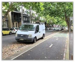
The cycleway is discontinuous. Over its 1.3 km length, it disappears in nine places forcing cyclists onto either the road or footpath. Excluding the shared cycle pedestrian path at the viaduct, the cycleway is non-existent for 845 metres. As shown in Table 1, there is no cycleway for 25% of the route heading east and 40% heading west.
| Table 1 | ||
| Cycleway section, heading East | Length (metres) | |
| Lyons Rd to Barr St | no cycleway | 35 |
| 196 Bridge Rd to Clare St | cycleway | |
| Clare St to Woolley St | no cycleway | 86 |
| Woolley St to 163 Bridge Rd | cycleway | |
| 163 Bridge Rd to Gottenham La | no cycleway | 204 |
| Gottenham La to 21 Bridge Rd (Burton St) | cycleway | |
| Subtotal (with no cycleway) | 325 | |
| Cycleway section, heading West | ||
| 22 Bridge Rd to viaduct | cycleway | |
| Viaduct to just before Railway Parade | footpath | 30 |
| Just before Railway Pde to Talfourd St | cycleway | |
| Talfourd St to opposite Rosebank St | no cycleway | 135 |
| Opposite Rosebank St to Opposite Woolley St | cycleway | |
| Opposite Woolley St to Hewitt Av | no cycleway | 50 |
| Hewitt Ave to Jarocin Ave | cycleway | |
| 198 Bridge Rd (after Jarocin Ave) to 250 Bridge Rd | no cycleway | 200 |
| 250-280 Bridge Rd, just before Junction St | cycleway | |
| 280 Bridge Rd to 304 Bridge Rd | no cycleway | 100 |
| 304 Bridge Rd to Barr St | cycleway | |
| Barr St to Lyons Rd | no cycleway | 35 |
| Subtotal (with no cycleway) | 550 | |
| Total length – no cycleway |
845 |
No parking is permitted along Bridge Rd. Table 2 below shows the distance between cross streets where residents might be able to find a park. The bolded streets are between Glebe Point Rd and Ross St. Residents here have particular difficulties because of the lack of back lanes and long distances between cross streets. The removal of all parking is particularly difficult for people with disabilities but also affects tradespersons, deliveries and removals.
| Table 2 | ||||
| Cycleway heading East | Length (metres) | Cycleway heading West | Length (metres) | |
| Lyons Rd to Cross St | 168 | Railway St to Gottenham St | 211 | |
| Cross St to Foss St | 114 | Gottenham St to Talfourd St | 59 | |
| Foss St to Ross St | 100 | Talfourd St to Glebe Pt Rd | 63 | |
| Ross St to Clare St | 223 | Glebe Pt Rd to Jarocin Ave | 340 | |
| Clare St to Woolley St | 84 | Jarocin Ave to Ross St | 148 | |
| Woolley St to Rosebank St | 100 | Ross St to Junction St | 182 | |
| Rosebank St to Glebe Pt Rd | 57 | Junction St to Barr St | 170 | |
| Glebe Point Rd to Talfourd St | 62 | Barr St to Lyons Rd | 33 | |
| Talfourd St to Gottenham St | 59 | |||
| Gottenham St to Burton St | 245 |
Planned Improvements
Transport NSW advised that the narrowing of the road for the pedestrian crossing at Woolley St is to be removed. This will allow the cycleway to be continuous heading east from Clare St to Woolley St (86 metres) and opposite Woolley St to Hewit Ave heading West (50 metres). This is an improvement. The cycleway will disappear in seven rather than nine places for a total length of about 700 metres.
The unsightly red paddles are to be replaced by a low kerb. Consideration is being given to the need for kerb crossings for users of prams, trolleys and wheelchairs.
We were advised that they were aware that the parking issues and regulation of parking are a Council of Sydney responsibility but a request would be made to Council to facilitate more car drop off and pickup and delivery zones in side streets.
Timing
The works to make the cycleway permanent will not commence until the current works to upgrade the power supply to the new fish market are completed. This is likely be after March 2023 at the earliest.
Other Options
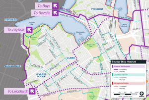
The Management Committee is particularly concerned about the stretch of cycleway between Glebe Point Rd and Ross St because of safety for cyclists and amenity for residents. However, it must be noted that not all our members share this view. The Sydney Bike Network map (Figure 1) proposes a regional bike way branching off Bridge Rd at Gottenham St and going to Bay St. We asked if the feasibility had been explored of using the proposed Gottenham St branch to divert the cycleway along St Johns Rd and Junction St thereby eliminating the most problematic stretch?
Transport NSW advised that this had been explored but was not considered feasible because bikes would have to cross Bridge Rd and because the direct route was preferred. They agreed to send the Society the feasibility study. The Society recommended that there be improved signage to make motorists more aware of the places where the bike path merges with the traffic stream. It was agreed that this would be investigated.
The Society recommended that there be improved signage to make motorists more aware of the places where the bike path merges with the traffic stream. It was agreed that this would be investigated.
We have received some correspondence from members on this issue: one supporting the cycleway and requesting a more balanced view from the Society and another suggesting we look at the Bourke St, Surry Hills cycleway as an example of a better design. I welcome this feedback.


3 comments. Please add yours.
Look forward to bridge Rd Cycleway being finished soon! I know some want different streets or no Cycleway, but as a regular bike commuter & Glebe local it’ll be excellent to have the bridge Rd Cycleway made permanent with dividers.Especially as it will link up with inner west Cycleways, the new Fishmarkets & onwards into city Cycleways. Can’t wait!
Thanks for the update! Two issues that have also been raised is the interruption to important service provision such as the NDIS. At least one resident reported that their in home care service has been limited because of the lack of local parking. This leads to the second issue which is why both sides of a road need to be dedicated to cycleways. The City of Sydney has several cycle ways where there is provision for bike traffic in both directions. This allows for parking / drop offs on the other side of the street.
I would like to see a study into the feasibility of a dual direction Bourke St style permanent intervention on the north side of bridge Rd to link up with blackwattle bay paths and also provide greater pedestrian protection near FLPS. This area frequently experiences vehicles hitting the barriers currently in place, putting vulnerable community members at risk.