
By Janet Oakley, Convenor, Transport and Traffic Subcommittee, Bulletin 5/2024, July
Several transport and traffic issues have recently been considered by the Management Committee.
WestConnex Rozelle Interchange
It became apparent after the opening of the Rozelle Interchange Project (RIP) that the effect on local surface roads is considerable and ongoing. In our submission to the Parliamentary Inquiry into the Impact of the Rozelle Interchange, we expressed our concerns about multiple issues affecting the Interchange. We have not yet received a response to our submission, which was submitted in early April. Some of the concerns we raised are discussed below.
Signage: Currently, most signs direct road users to the tunnel or the City; there are very few signs helpful to those headed south or west. Where there are such signs, their locations mean the sign is seen too late to enable safe decisions, and they are often confusing and, in some instances, inaccurate.
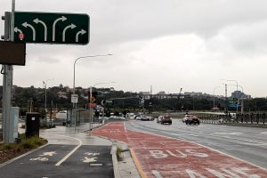
An example of misleading and potentially dangerous signage is before the traffic lights at Victoria Road and City West Link. The large overhead sign (see photo below) indicates three lanes turn left and three turn right from Victoria Road, suggesting that a vehicle in the middle lane travelling south could turn right without changing lanes. In fact, that is not correct. The only way to turn right without changing lanes is to be in the far right lane.
Another example of poor signage is the merger of eastbound traffic into one lane under the Light Rail overpass on The Crescent, where two lanes suddenly become one without prior warning.
North-south traffic: For southbound traffic at the White Bay intersection, both lane marking and signage are very confusing. The effect is to channel all southbound traffic into suburban streets: The Crescent (which becomes Ross Street) and Johnston Street. Neither of these streets was designed for the amount of traffic and size of vehicles they now carry; neither has ever been an arterial road. Traffic banks up along The Crescent and Ross Street at peak periods, compounded by changes made at the intersection of Ross Street and Parramatta Road. There is also a perceptible increase in very heavy vehicles along these streets.
Vehicles heading north from The Crescent to Victoria Road face a long wait at peak periods because the traffic light phasing prioritises east-west traffic. This also leads to a build-up of traffic during peak periods. Ramp signals – traffic signals that can be set to control the number of cars allowed through on the green light – are apparently in place but only control traffic flow onto the Anzac Bridge approach.
East-west local roads being used as avoidance ‘rat runs’: There has been a noticeable increase in traffic on east-west local roads through Glebe and Forest Lodge since RIP opened, particularly Wigram Road, Bridge Road and Parramatta Road. No doubt motorists are seeking to avoid the bottlenecks on the RIP surface roads – that is, above-ground roads, as opposed to tunnels – when driving to and from the City, particularly at peak periods. In fact, Transport for NSW encourages drivers to use Parramatta Road as an un-tolled route to the City (https://www.transport.nsw.gov.au/projects/current-projects/rozelle-interchange).
Foot and cycle traffic: The removal of the pedestrian crossing on Victoria Road at Robert Street has created a hazard for people trying to access Balmain from the 433 bus stop opposite the White Bay Power Station.
Air quality: It is of concern that the Secretary of the Department of Planning and Environment has been granted the discretion to apply flexibility in the ambient air quality monitoring timeframe. (Modification of Infrastructure Approval 23/8/2023).
New bus timetables
New bus timetables have recently been implemented for all Glebe–Forest Lodge routes. There was no consultation before changes were made. An audit of the changes reveals that they are insignificant. However, the changes seem to reinforce a previous trend – that is, buses on different routes are scheduled to arrive at stops in Glebe–Forest Lodge at the same time. For instance, the 469 bus (which was supposed to make up for the cancellation of the Leichhardt Market Place/Glebe Point Road leg of the 370 service) is scheduled to arrive at stops on the route of the 433 at the same time or within minutes of the 433. The 469 only comes every 30 minutes, and if it was staggered so that it did not coincide with the 433 service, it would provide a more regular service for passengers trying to get between Forest Lodge and Glebe Point Road. The 433 service is more frequent but is plagued with cancellations. Similarly, the 370 and 431 which both cover Glebe Point Road, are scheduled within minutes of each other. For this reason, the gap between buses along Glebe Point Road is nearly always 20 minutes.
The simultaneous scheduling of bus services that cover the same route appears to be a deliberate policy on the part of the service providers and effectively reduces the available services.
We have written to our local State member, Kobi Shetty, to draw her attention to these issues, and we look forward to her response. Clearly, this should not preclude others from raising their own concerns.
Bridge Road cycleway
There has been a call for Expressions of Interest from contractors to construct the Bridge Road Permanent Cycleway (https://shorturl.at/AMbEZ). Interestingly, the closed tender documents can only be accessed if the prospective contractor signs a document called a ‘Confidentiality Deed Poll (One Way)’.
We hope that the Glebe Society’s efforts to address these transport and traffic issues will result in improvements that benefit our Glebe–Forest Lodge community. I’ll keep you posted!


One comment. Please add yours.
Thank goodness for the commitment & determination of folk like Janet .. what a shocker the whole Transport Department has proved to be !.. I was always ready to criticise the State govt- there’s plenty to be unhappy about there – but the bureaucracy is the true culprit – of course no one is to blame !