
By Asa Wahlquist, Bays & Foreshores Convenor and Ian Stephenson, Planning Convenor, September 2021, from Bulletin 7 of 2021
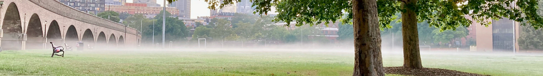
Blackwattle Bay is one of the defining features of Glebe. It opens the suburb up to the sky and the water gives the suburb a wonderful aspect and the opportunity for water sports like rowing, dragon boating and canoeing. The incredible popularity of the foreshore walk, particularly in pandemic times, is due to its proximity to the water and the sense of space and relaxation that it brings.
The proposed development should improve our local environment, but it fails on every measure.
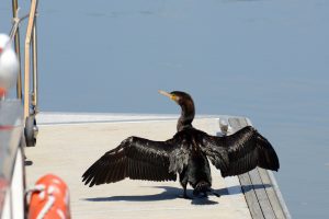
Blackwattle Bay once extended almost as far as Broadway, fed by Blackwattle Creek which had tributaries originating in Victoria Park and the University of Sydney. It was a mangrove forest that extended back where Wentworth Park is today. It was a varied environment with rocky ledges, sandy beaches, and sloping foreshores. It was host to a great diversity of fish and marine organisms. Shane Phillips, from the Tribal Warrior moored on the Pyrmont side of Blackwattle Bay, told the gathering at a smoking ceremony for the new Sydney Fish Markets, that the mangrove forest was the fish market in pre-settlement times. This is a critical part of the area’s First Nations heritage.
But none of this is referenced in the Plan. Redeveloping the current Fish Market site offers an unparalleled opportunity to restore the Bay, to provide access to the community, and to alter the sea walls to increase habitat for marine life. Instead, the northern side of the Bay is banked with marinas, the Bay contained by solid vertical sea walls, the construction of the new Sydney Fish Market further separating the Bay from Wentworth Park. Improvements can be made. Just look around in the next bay, Rozelle Bay, where Sydney Water is rehabilitating Johnstons Creek. It is replacing a walled concrete channel with sloping rock beds, walls of differing heights and creating a range of niches to support and encourage a wider variety of marine and botanic life.
Heritage comes in many forms, including the Glebe Rowing Club, the third oldest rowing club in Australia, founded in 1879. For over 150 years the local water sports clubs have provided the local community with inclusive and affordable access to the Bay. The section of the report dealing with Heritage makes no mention of this. The current water users, which include members of the Glebe Rowing Club, the Sydney University Women’s Rowing Club and the Blackwattle Bay Dragon Boat Club, as well as canoers, kayakers, paddle boarders and sailors, access Blackwattle Bay for sport and recreation every day. But instead of giving the community greater access to the waters of Blackwattle Bay, the proposal hands valuable water space to corporate and charter marinas. Large motorised boats could cause problems, stirring up silt and creating navigational challenges for passive water users, like rowers and dragon boaters.
As industry has moved out of Blackwattle Bay the water quality has improved. Over 25 fish species and 50 other organisms, including oysters, shrimp, limpets, sponges and algae have been found in the Bay. Increased numbers and movements of large motor boats and commercial craft have the potential to stir up the sediment, which contains toxins, including the heavy metals mercury, lead, zinc and copper, and other contaminants such as asbestos, arsenic, polycyclic aromatic hydrocarbons and total petroleum hydrocarbon. All these have been found in the sediments at levels that exceed both ‘low and high trigger value sediment quality guidelines protective of ecological communities.’ (DA for Stage one of the New Sydney Fish Markets: EIS 7.10.3, p. 156). It is imperative that the Bay’s marine environment improves and does not deteriorate as the development proceeds.
The Glebe Society is justifiably proud of its role in fighting to create the foreshore walk and associated parklands. We look forward to the day when our foreshore walk is connected with that in Pyrmont, though it will be interrupted by the new Sydney Fish Market. The planned foreshore walk is a bitter disappointment. It is touted as the missing link in the Woolloomooloo to Rozelle Bay walk, but it is too narrow, at only 10 metres wide, to provide for many people who will use it. These will include pedestrians, shoppers and tourists milling about, cyclists, parents pushing strollers, wheelchair users and people walking dogs. If the Glebe foreshore is any indication, the proposed walk will come under heavy pressure.
The Glebe Society also objects to the promenade being a shared path (shared by both pedestrians and bicycles) which has been shown not to work on the Glebe foreshore walk. It needs to be at least 30 metres wide to accommodate so many different users, and to allow for separate paths for pedestrians and cyclists. The path will also be overshadowed by the many crowded buildings of the development and the Anzac Bridge; in winter, it will be late morning before the sun strikes it. And users will be buffeted by the winds channelled between the towers. The City of Sydney has produced a map indicating 13 places on the proposed Plan that are unsafe, while 27 are not comfortable walking. It also argues that standing and sitting comfort is not considered.
The proponents state that 30 per cent of the site will be open space, but many of the so-called parks are pockets between buildings. As a result, the City of Sydney states the sunlight in the proposed parks is less than the City’s requirements and few, if any, streets will have enough sunlight to grow the proposed tree cover. The most recent inner-city foreshore development, Barangaroo, allocated 50 per cent of the area to open space. The Blackwattle Bay development should follow suit and bring an actual benefit to the Glebe Community.
It should also be noted that there are plans to develop the large swathe of State Government-owned land along the adjacent Rozelle, White and Johnstons Bays. While the White Bay plan is in the early stages, the draft strategy includes illustrations of yet more high-density buildings. The Glebe Society fears the Bays could end up ringed with towers, with only our heritage standing between Glebe and overdevelopment.
The Glebe Society’s submission in opposition to the Blackwattle Bay Planning ProposalThe Glebe Society has lodged a detailed submission opposing the Blackwattle Bay Planning Proposal (https://www.glebesociety.org.au/blackwattle-bay-ssp-submission/). The Society recommends that the planning of Blackwattle Bay should be based on the preparation of a Master Plan and that the terms of reference of the Master Plan must include the following requirements:
The Master Plan should be placed on public exhibition and the City of Sydney should be the consent authority for the development. |
The Blackwattle Bay State Significant Project
Infrastructure NSW’s proposal for Blackwattle Bay brings to mind the final lines of the poem Wet Day by James McAuley: ‘I think the world has never been redeemed; at least the marks it bears are mainly of the Beast – the broken trust, the litter and the stink’.
The scheme provides for the redevelopment of the old Fish Market site and adjoining land, including buildings up to 45 storeys high (Fig. 1). It proposes fast-tracking the planning process by making the precinct a State Significant Development. Although a background study identified the need for ‘a well-designed fine-grain network comprising streets, laneways and arcades which will enhance the accessibility of the waterfront and permeability of the precinct’, the proposal is for 12 buildings as follows:

1 x 45 storey building 156 metres
1 x 32 storey building 120 metres
1 x 30 storey building 110 metres
2 x 25 storey buildings 91.5 metres
1 x 20 storey building 75.5 metres
1 x 19 storey building 72 metres
1 x 17 storey building 65 metres
2 x 10 storey buildings 37.5 metres
2 x 5 storey buildings 21 metres
The height controls in the current Sydney City Council LEP provide for a maximum of 33 metres (nine storeys) and relate to nearby buildings. There is no justification for changing this to a maximum height of 156 metres, a height only found in the CBD. The urban form of Pyrmont should step down to the waterfront and not enclose it with a wall of very high buildings.
The apartments in the new buildings will suffer from unacceptable noise and air pollution levels from the Western Distributor and do not meet standards for cross ventilation and will therefore be reliant on mechanical cooling.
Blackwattle Bay is to be a 24-hour activity precinct. This is incompatible with a residential district, and as sound carries across water, the residents of both Pyrmont and Glebe will be affected.
Infrastructure NSW identified Blackwattle Bay as ‘an extraordinary opportunity to reconnect the harbour, its surrounding neighbourhoods and the city; to showcase Sydney’s living culture and stories of Country; to build an inclusive and iconic waterfront destination that celebrates innovation, diversity and community’. However, the planning fails miserably to do this.
The Western Distributor is currently a shadowy chasm separating Pyrmont from the Bay. It destroys the legibility of Pyrmont as a peninsula, is a gloomy wasteland and feels like an unsafe area to walk in. However, its shortcomings could be ameliorated with clever planning.
The views to the west, with the Harbour in the foreground and Glebe Point in the distance framing the horizon, are picturesque. There is great potential to open up these vistas. It is a distinguished, indeed, a painterly outlook that allows the Distributor, with its vertical stanchions and horizontal roadway, to be read as a frame enclosing a magnificent landscape. The proposal does not take advantage of these opportunities. Apart from a narrow slot of open space to the Bay on the Miller St axis it will make the Distributor’s undercroft even more depressing by enclosing it with a wall of buildings.
It is claimed that the public can be confident that the development will be good urban planning because principles of good design will test the detailed designs for the buildings. This is fallacious. The building envelopes in the planning proposal are too dense and too tall. Good design is about considering all the elements, including impact on the neighbouring buildings, ameliorating the gash of the Western Distributor and managing scale, sunlight, amenity, noise and the promenade. This proposal is primarily driven by density. The scheme is fatally flawed because it starts with bad design. It is misleading to claim that a bad plan can be rectified by a design code. It cannot.
One of the objectives allegedly underpinning the proposal is to ‘embed and interpret the morphology, heritage and culture of the site to create an authentic and site responsive place’. However, the development is so dense it destroys the form of the place, particularly the relationship of the eastern edge of Blackwattle Bay to the Pyrmont peninsula. The Precinct Study also identifies ‘the need to better represent and engage knowledge and values of First Nations’ and says the precinct should ‘celebrate the cultural importance of Blackwattle Bay to the Wangal and Gadigal people’. The stories of the traditional owner’s connection with the land will be richer if the topography remains legible.
The NSW Environmental Planning and Assessment Act charges the Government with the responsibility
to promote the social and economic welfare of the community and a better environment by the proper management, development and conservation of the State’s natural and other resources, to facilitate ecologically sustainable development by integrating relevant economic, environmental and social considerations in decision-making about environmental planning and assessment and to promote good design and amenity of the built environment.
This proposal fails to do those things because it is completely skewed towards the provision of high density so that the State government can sell its land at the highest price. It is devoid of vision both for the present and the future. If it proceeds, it will go down with the Cahill Expressway as one of Sydney’s biggest planning blunders.
Of course, Infrastructure NSW paints a different picture. They say its vision is for ‘reconnecting the harbour, its surrounding neighbourhoods and the city; showcasing Sydney’s living culture and stories of Country; building an inclusive and iconic waterfront destination that celebrates innovation, diversity and community and delivering a green harbourside and a place for people’.
James McAuley’s poem Wet Day was inspired by another bay, a bay on the Derwent River in Hobart, but his closing lines, I think the world has never been redeemed; at least the marks it bears are mainly of the Beast – the broken trust, the litter and the stink, apply equally well to the spin and reality of Infrastructure NSW’s Blackwattle Bay Planning Proposal.


One comment. Please add yours.
Totally agree with your assessment. The initial public consultation was also close with a choice of 3 bad options rather than a real consultation.
Do we have any update on the review?
Best regards,.. Florence