
by Ian Stephenson, 3 September 2020
Ian has recently returned to Forest Lodge after a 20-year absence. He is a museum curator by profession and has been Senior Curator with the National Trust (NSW), Director of Historic Places in Canberra and CEO of the National Trust for South Australia. He is passionate about Glebe and keeping its special qualities, both architectural and social.
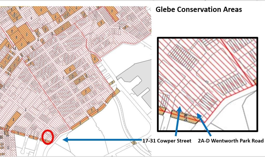
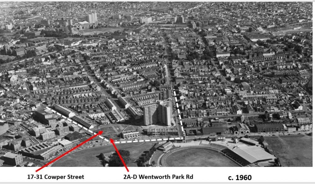
Readers of the Society’s Bulletin will be aware of the proposal to excise 2A-D Wentworth Park Rd and 17-31 Cowper St, Glebe from the St Phillips Heritage Conservation Area in order to change the existing height limit of 9 metres to 36 metres. This is to allow the demolition of a two-storey flat building and four 1980s terrace houses and their replacement by two eight-storey apartment buildings.
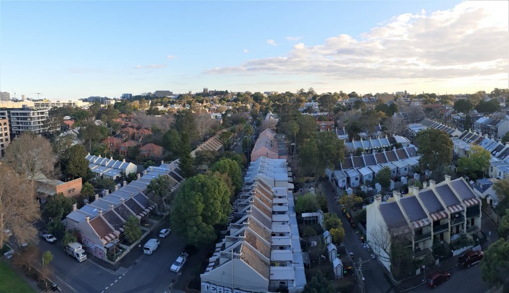
The St Phillips conservation zone comprises the area bounded by Campbell Lane, St Johns Rd, Wentworth Park Rd, Cowper St the eastern boundary of 52 Glebe St and the rear boundary of properties 64-92 Cowper St.
It was owned by the Anglican Church from 1828 until 1974. In the 1920s the land was seen as being too valuable for residential purposes1 but the Church resisted overtures to sell. After the Second World War the Cumberland County Planning Scheme placed nearly all of Glebe under great pressure, partly for the planned construction of two expressways and partly for `slum clearance’. Additional impetus for development came with the passage of the Conveyancing (Strata Titles) Act, 1961 which, in other parts of Glebe, led to the demolition of some houses for the construction of three storey strata titled home units.
Glebe was becoming an endangered species, but in the last half of the 1970s the tide rapidly turned. In April 1974 the Federal Government, under the leadership of the Minister for Urban and Regional Development, Tom Uren, announced the St Phillips and Bishopsthorpe estates would be purchased from the Church of England. In November the National Trust listed most of Glebe as a conservation area noting it contains the largest continuous number of 1860s and 70s cottages and terraces forming a continuous townscape in Australia [and] it is handsome, coherent and largely complete [because its] scale and character have been little disturbed by modern intrusion.2 Then in 1977 with the election of the Wran government the expressways were scrapped.
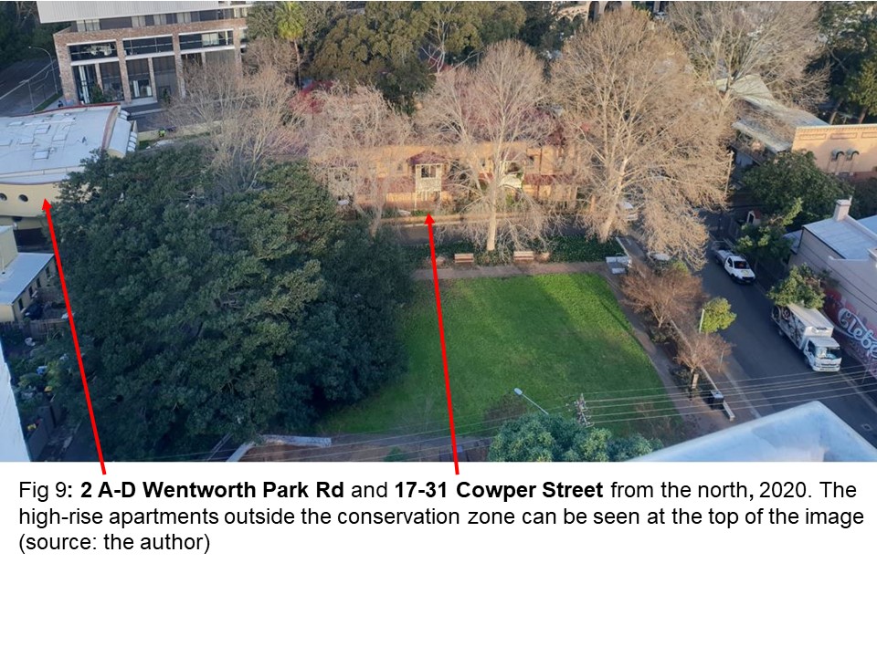
The Federal Government’s Glebe Project included the conservation and renovation of over 700 houses. It was the first time in Australia that a government had provided low income housing by rehabilitation rather than development. The work was of very high quality.
In 1985 the Glebe estate was transferred to the NSW Government. The NSW Housing Commission’s in-house architects designed infill housing which reflected the form and scale of the Glebe townscape. They brought great skill to the task. The two buildings proposed for demolition are part of their work.
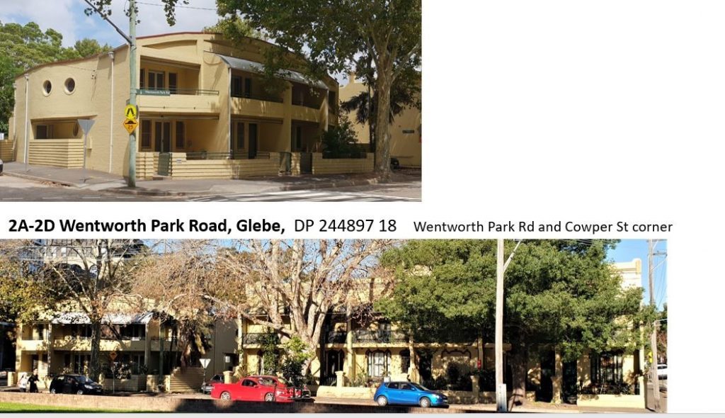
The scheme at 2A-2D Wentworth Park Rd provides four three-bedroom terrace houses which have been designed to fit in with the adjoining row of six mid-Victorian terraces, Premier Terrace.
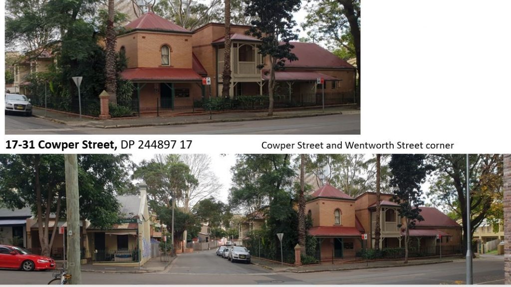
The neighbouring flat building at 17-31 Cowper St, Glebe is an unusually sophisticated response to the aesthetic of place in the way it uses scale, texture, modelling, pattern, vicinity and variety to respond to the historic townscape. It is also well considered in terms of amenity and livability. It is beautifully detailed and provides its tenants with private open space, as well as shared open space. It represents a level of care, imagination and respect for both residents and the townscape which is unusual. It should not be demolished.
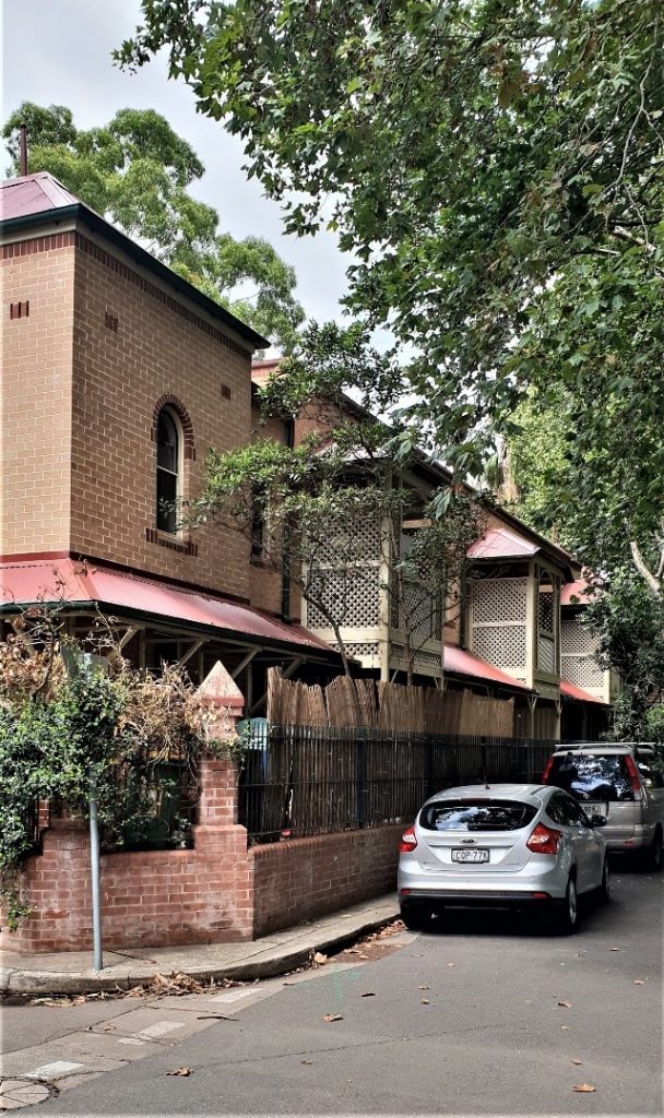
Fig 6. The courtyard at 17-31 Cowper St (source: Ian Stephenson) 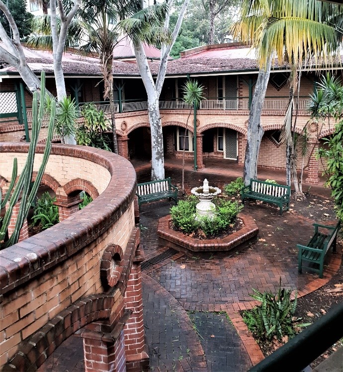
Fig 7. the Courtyard (source: Ian Stephenson)
The Physical Context
The Proposal
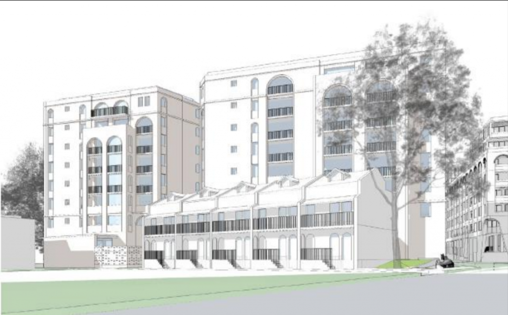
Fig 12: The elevation of the proposed buildings facing the Paddy Doherty Reserve, viewed from Wentworth St (source: City of Sydney) 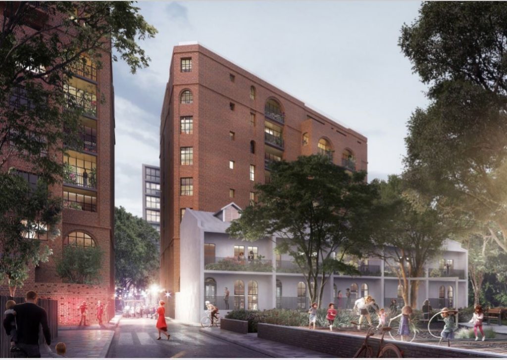
Fig 13: The building on the left will be for housing department tenants, the building on the right is private housing, (source: Prince’s Trust Australia)
The existing buildings comprise 4 x 3 bedroom houses at 2 Wentworth Park Rd, and flats with a total of 15 bedrooms at 17-31 Cowper St, making a total of 27 bedrooms. The social housing component of the proposed development will include 42 bedrooms, a net increase of 15. The existing accommodation includes private open space, public open space and fits in with the context of the neighbouring houses. These features, which add to the liveability and amenity of the dwellings, will be absent in the new scheme.
Its Impact
One of the things which gives Glebe its identity and makes it a place of exceptional heritage significance is, that with a small number of exceptions, its late 19th century scale and topography remain intact. The controls for the St Phillips Conservation Area identify the 1959 11-storey John Byrne Court as a detracting element and provide height limits to prevent new buildings destroying the scale of Glebe.
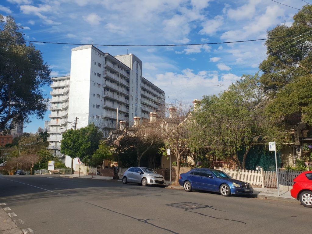
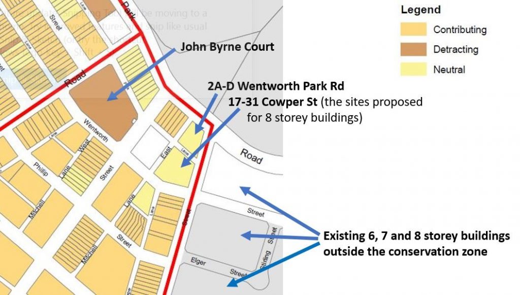
The construction of two 8-storey buildings within the St Phillips estate changes John Byrne Court from being a non-conforming element to one of three high rise buildings and opens the way to more high rise being built on the Land and Housing Corporation (LAHC) infill sites, the buildings designated as neutral on the above map.
There has been an attempt to make the scheme more acceptable to the character of the Glebe by designing the buildings to look like Edwardian brick warehouses. Such buildings are characteristic of Ultimo and Pyrmont, not Glebe. Their construction in the St Phillips estate is quite contrary to the planning goal of nurturing Sydney as a city of villages drawing on the unique character of each area, including topography, landscape, street and park layout, setting, public buildings, heritage, streetscape, land uses and buildings as it blurs the distinct identities of Glebe and Ultimo.
The Prince’s Trust Australia, who were commissioned by the NSW State Government to work on the project, claim in their website that the development responds to the local character of Glebe and shows how new housing can be sensitively built in an established inner-city neighbourhood. This project will be sustainable, respect local character and create a mixed-income community which includes social and affordable housing3. It is bitterly ironic that the infill housing which is being demolished is an exemplar of how new housing can be sensitively built in an established neighbourhood and the scheme proposed to replace it does not respect local character.
The scheme should be opposed for many reasons. These include: the demolition of post 1974 public housing, which is recognised in the Local Environment Plan (LEP) as being of heritage significance (this is particularly regrettable in respect of the building at 17-31 Cowper St which is of high architectural merit); destroying the scale of this part of Glebe by creating a precinct of three high rise buildings; creating a precedent for more high rise development on the 1980s infill sites and blurring the architectural character of Glebe and Ultimo.
In addition, it only provides an additional 15 social housing bedrooms and these with less amenity than the 27 currently on the site.
Other Options
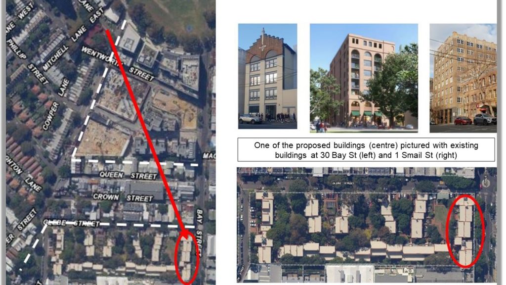
The present proposal can be summarised as being the wrong thing in the wrong place. A better alternative exists. That is to relocate the two 8-storey towers to the Land and Housing Corporation site at 45-51 Bay St, Glebe. This large site is not in a conservation zone and adjoins Edwardian brick warehouse style buildings so that the new buildings will better match the identity of the neighbourhood.
The Next Steps
The rezoning of 2A-D Wentworth Park Rd and 17-31 Cowper St will be placed on public exhibition and be available for comment. If you share my concerns please ensure you make a response.
Notes: 1. The Argus, 27 March, 1920, p. 20. 2. This was a non-statutory listing but became the basis for listing by Leichardt Council and was the genesis of the heritage conservation areas in the current City of Sydney LEP. 3. Prince’s Trust website, Princes Quarter Glebe, see https://www.princes-trust.org.au/current-projects/


One comment. Please add yours.
John Byrne court is 12 story not 11.